.

Algeria 200/1
Algeria. Star Dunes in Algeria. The image was acquired by the Advanced Spaceborne Thermal Emission and Reflection Radiometer (ASTER) on NASA’s Terra satellite on October 27, 2012. It was made from a combination of near-infrared and visible light. In this type of false-color image, sand is tan and shadows are black or gray. The blue-tinted areas are likely mineral-rich evaporites. The image is centered at 29.8°north latitude, 7.9°east longitude, near the town of Gadamis. As is common with star dunes, some of the dunes have long interlacing arms connecting to nearby dunes: image by NASA/GSFC/METI/ERSDAC/JAROS/ U.S./Japan ASTER Science Team (NASA)

Argentina 4/1
Argentina. Paraná River Floodplain, Northern Argentina. The Paraná River is South America’s second largest, and the river and its tributaries are important transportation routes for landlocked cities in Argentina, Paraguay, Bolivia, and Brazil. This astronaut photograph shows a 29-kilometer (18 mile) stretch of the Paraná, downstream of the small city of Goya, Argentina (just off the top left of the image): image by NASA Earth Observatory (NASA), 9 April 2011

Brazil 3/1
Brazil. Sao Simao Reservoir, Brazil is featured in this image
photographed by an Expedition 16 crew member on the International Space
Station (ISS). The Sao Simao reservoir, near the confluence of the Rio
Paranaiba and Rio Verde in Brazil, is the featured subject in a
milestone image of Earth. This colorful, patchwork image is the
300,000th image of Earth downlinked from the space station. There are
now over 745,000 images of Earth taken by astronaut crews, beginning
with the Mercury missions in 1961 and continuing to the present day on
the ISS. The Sao Simao reservoir is located on the border
between the states of Goias and Minas Gerais (near the geographic
coordinates of 18.7S 50.4W). Though the town of Sao Simao was founded
around 1935, major growth occurred when the hydroelectric power plant
and dam were built - forming the reservoir -- in 1975. The reservoir is
part of a major navigation link that allows transport of goods and
commerce between central Brazil, the Prata River and the South Atlantic.
With 600,000 square kilometers of surface area, the reservoir also
serves as a tourist destination for fishing, swimming and boating. In
addition to hydroelectric power production, the economy of the region is
based in agribusiness. The image highlights agricultural fields of
various kinds and in different stages of cultivation. The major
commodities include corn, soybeans, sesame seeds, sugarcane, beans,
manioc, coffee and meat production: image by NASA/ISS, 11 June 2014 (NASA)

Chile 28/1
Chile. Lluta River, Chile. A remote plateau in far northern
Chile is not a place you want to be without water. Large sections of
the Atacama Desert -- often called the driest place on Earth -- receive less
than a millimeter of rain per year. The town of
Arica -- which lies along the Pacific coast, about 15 miles (24 kilometers)
west of the area shown here -- has the lowest average precipitation of any
city in the world. Arica survives on just .03 inches (0.8 millimeters)
of rain per year, about 75 times less than what California’s Death
Valley receives.The barren nature of the landscape was on
full display on July 19, 2012, when the Advanced Land Imager (ALI) on
NASA’s Earth Observing-1 satellite acquired this image. Although a few
types of cacti and other drought-tolerant species can survive in the
Atacama, surfaces appear vegetation-free from ALI’s perspective, leaving
a veneer of tan to dominate the image: image by NASA Earth Observatory (NASA)

Colombia 20/1
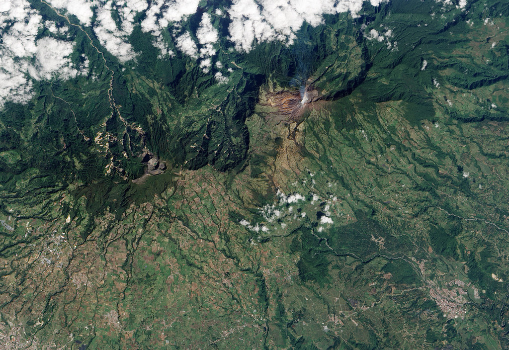
Colombia. Eruption of Nevado Del Ruiz. Nevado del Ruiz
Volcano, infamous for its deadly lahars, sprang to life in March 2012.
Located in the Colombian Andes, the volcano was frequently active during
the past 1,000 years, most recently in 2010. Observers first reported
earthquakes near the volcano, followed by emissions of volcanic gases
and small amounts of ash. By early June sulfur dioxide emissions had
increased, and ash reached as far as 40 kilometers (25 miles) from the
volcano. This natural-color satellite image shows a burst
of ash from Nevado del Ruiz on June 6, 2012. It was acquired by the
Advanced Land Imager (ALI) aboard the Earth Observing-1 (EO-1)
satellite: image by NASA Earth Observatory (NASA)
Costa Rica 50/1
Costa Rica. Unrest at Turrialba Volcano, Costa Rica. Turrialba Volcano, located in central Costa Rica, emits a translucent plume of volcanic gases in this natural-color satellite image from January 21, 2010. According to the RED Sismológica Nacional (Costa Rican National Seismological Network), activity at the volcano increased markedly on January 4, 2010. Strong, long-lasting volcanic tremors were accompanied by gas plumes over the volcano, and emissions of ash began on January 5th. The “jet-type noise” of gas and ash rushing out of fumaroles was heard several kilometers away. On January 21, Nacion.com reported that potato and carrot farmers were asked to leave fields near the volcano’s summit due to further increases in gas emissions. The barren summit region of the 3,340-meter- (10,960-foot-) high Turrialba appears gray and brown, while the volcanic plume is a hazy blue. Fields and pastures are light green, in contrast to dark green forest that covers the high-elevation ridges. Since 2007, frequent acid rain showers caused by activity at the volcano killed or damaged much of the vegetation to the southwest of the summit, leaving the area brown and orange. This image was acquired by the Advanced Land Imager (ALI) aboard NASA’s Earth Observing-1 (EO-1) satellite: image by NASA Earth Observatory (NASA)

Mexico 33/1
Costa Rica 50/1
Costa Rica. Unrest at Turrialba Volcano, Costa Rica. Turrialba Volcano, located in central Costa Rica, emits a translucent plume of volcanic gases in this natural-color satellite image from January 21, 2010. According to the RED Sismológica Nacional (Costa Rican National Seismological Network), activity at the volcano increased markedly on January 4, 2010. Strong, long-lasting volcanic tremors were accompanied by gas plumes over the volcano, and emissions of ash began on January 5th. The “jet-type noise” of gas and ash rushing out of fumaroles was heard several kilometers away. On January 21, Nacion.com reported that potato and carrot farmers were asked to leave fields near the volcano’s summit due to further increases in gas emissions. The barren summit region of the 3,340-meter- (10,960-foot-) high Turrialba appears gray and brown, while the volcanic plume is a hazy blue. Fields and pastures are light green, in contrast to dark green forest that covers the high-elevation ridges. Since 2007, frequent acid rain showers caused by activity at the volcano killed or damaged much of the vegetation to the southwest of the summit, leaving the area brown and orange. This image was acquired by the Advanced Land Imager (ALI) aboard NASA’s Earth Observing-1 (EO-1) satellite: image by NASA Earth Observatory (NASA)
Mexico 33/1
Mexico. Monterrey, Mexico. In northeastern Mexico’s Nuevo
Leon state, the Sierra Madre Oriental (Eastern Sierra Madres) cluster in
densely packed rows of arcing ridgelines. Just to the southwest of the
city of Monterrey, these west-to-east running ridges make a sharp bend
toward the south. The mountains then continue southward roughly parallel
to the Gulf Coast for hundreds of miles.This image of
the region around Monterrey was captured by the Enhanced Thematic Mapper
Plus sensor on NASA’s Landsat satellite on November 28, 1999. The dry
terrain at lower elevations in the image appear in shades of tan and
brown, while on the sharp ridges, vegetation appears dull to deep green.
The urban development of Monterrey makes a gray patch at the foothills
of the mountains. A river winds its way through the ridges as a tan
ribbon:
NASA image created by Jesse Allen, Earth Observatory, using data
obtained from the University of Maryland’s Global Land Cover Facility (NASA)

Netherlands 8/1
Netherlands. Den Helder, Netherlands is featured in this image photographed by an Expedition 15 crewmember on the International Space Station. The city and harbor of Den Helder in the northern Netherlands has been the home port of the Dutch Royal Navy for over 175 years. Its favorable location provides access to the North Sea, and has made it an important commercial shipping port in addition to its strategic role. Bright red agricultural fields to the south of Den Helder indicate another noteworthy aspect of the region--commercial farming of tulips and hyacinth. This image is an oblique view--the camera is oriented at an angle relative to "straight down"--of the Den Helder region taken from the space station, which was located to the southeast, near Dulmen, Germany (approximately 225 kilometers away in terms of ground distance) when the image was acquired. In addition to the manmade structures of the Den Helder urban area (reddish gray to gray street grids) and dockyards to the east of the city, several striking geomorphic features are visible. The extensive gray mudflats, with their prominent branching pattern (top right), indicate that this image was acquired at low tide, and suggest thegeneral low elevation of the region. Parallel wave patterns along the mudflats and in the Marsdiep strait are formed as water interacts with the sea bottom between Den Helder and Texel Island during tidal flow. Some ship wakes are also visible. According to scientists, the bright white-gray triangular region at the southern tip of Texel Island (bottom center) is a dune field, consisting mainly of eolian (windborne) sands deposited during the last ice age. Subsequent sea level rise and shoreline processes have mobilized and re-deposited these sands into their current configuration -- including a new dune field island to the southwest of Texel (bottom center): image by NASA/ISS, 11 June 2014 (NASA)

Nigeria 200/1
Nigeria. Once serving as part of the floor for a much larger Lake Chad, the area now known as the Bodele Depression, located at the southern edge of the Sahara Desert in north central Africa, is slowly being transformed into a desert landscape. In the mid-1960s, Lake Chad was about the size of Lake Erie. But persistent drought conditions coupled with increased demand for freshwater for irrigation have reduced Lake Chad to about 5 percent of its former size. As the waters receded, the silts and sediments resting on the lakebed were left to dry in the scorching African sun. The small grains of the silty sand are easily swept up by the strong wind gusts that occasionally blow over the region. Once heaved aloft, the Bodele dust can be carried for hundreds or even thousands of kilometers. The remnants of Lake Chad appear as the olive-green feature set amid the tan and light brown hues of the surrounding landscape where the countries of Chad, Niger, Nigeria, and Cameroon all share borders. The Bodele Depression was the source of some very impressive dust storms that swept over West Africa and the Cape Verde Islands in early February. These true-color images were acquired by the Moderate Resolution Imaging Spectroradiometer (MODIS) on February 7, and February 11, 2004. Numerous fires are shown as red dots in the February 7 images: image by Jacques Descloitres, MODIS Rapid Response Team, NASA/GSFC (NASA)

Netherlands 8/1
Netherlands. Den Helder, Netherlands is featured in this image photographed by an Expedition 15 crewmember on the International Space Station. The city and harbor of Den Helder in the northern Netherlands has been the home port of the Dutch Royal Navy for over 175 years. Its favorable location provides access to the North Sea, and has made it an important commercial shipping port in addition to its strategic role. Bright red agricultural fields to the south of Den Helder indicate another noteworthy aspect of the region--commercial farming of tulips and hyacinth. This image is an oblique view--the camera is oriented at an angle relative to "straight down"--of the Den Helder region taken from the space station, which was located to the southeast, near Dulmen, Germany (approximately 225 kilometers away in terms of ground distance) when the image was acquired. In addition to the manmade structures of the Den Helder urban area (reddish gray to gray street grids) and dockyards to the east of the city, several striking geomorphic features are visible. The extensive gray mudflats, with their prominent branching pattern (top right), indicate that this image was acquired at low tide, and suggest thegeneral low elevation of the region. Parallel wave patterns along the mudflats and in the Marsdiep strait are formed as water interacts with the sea bottom between Den Helder and Texel Island during tidal flow. Some ship wakes are also visible. According to scientists, the bright white-gray triangular region at the southern tip of Texel Island (bottom center) is a dune field, consisting mainly of eolian (windborne) sands deposited during the last ice age. Subsequent sea level rise and shoreline processes have mobilized and re-deposited these sands into their current configuration -- including a new dune field island to the southwest of Texel (bottom center): image by NASA/ISS, 11 June 2014 (NASA)
Nigeria 200/1
Nigeria. Once serving as part of the floor for a much larger Lake Chad, the area now known as the Bodele Depression, located at the southern edge of the Sahara Desert in north central Africa, is slowly being transformed into a desert landscape. In the mid-1960s, Lake Chad was about the size of Lake Erie. But persistent drought conditions coupled with increased demand for freshwater for irrigation have reduced Lake Chad to about 5 percent of its former size. As the waters receded, the silts and sediments resting on the lakebed were left to dry in the scorching African sun. The small grains of the silty sand are easily swept up by the strong wind gusts that occasionally blow over the region. Once heaved aloft, the Bodele dust can be carried for hundreds or even thousands of kilometers. The remnants of Lake Chad appear as the olive-green feature set amid the tan and light brown hues of the surrounding landscape where the countries of Chad, Niger, Nigeria, and Cameroon all share borders. The Bodele Depression was the source of some very impressive dust storms that swept over West Africa and the Cape Verde Islands in early February. These true-color images were acquired by the Moderate Resolution Imaging Spectroradiometer (MODIS) on February 7, and February 11, 2004. Numerous fires are shown as red dots in the February 7 images: image by Jacques Descloitres, MODIS Rapid Response Team, NASA/GSFC (NASA)
Switzerland 80/1
Switzerland. Bernese
Alps, Switzerland is featured in this image photographed by an
Expedition 13 crew member onboard the International Space Station. The
formidable mountain system of the Alps stretches across much of central
Europe, with seven countries claiming portions of the mountains within
their borders (Germany, France, Switzerland, Italy, Liechtenstein,
Austria, and Slovenia). The glacial landscape of the Bernese Alps,
located in southwestern Switzerland, is well illustrated by this view. The
image was taken by a crewmember looking north-northwest while the
station was located over the Mediterranean Sea between Corsica and Italy
-- this oblique viewing angle imparts a sense of perspective to the
image. This type of viewing angle complements more nadir
(downward)--viewing imagery of the region. Three of the higher peaks of
the central Alps are visible--Jungfrau (4,158 meters), Moench (4,089
meters), and Eiger (3,970 meters). To the east and south of the Jungfrau
is the Aletsch Glacier, clearly marked by dark medial moraines
extending along the glacier's length parallel to the valley axis. The
moraines are formed from rock and soil debris collected along the sides
of three mountain glaciers located near the Jungfrau and Moench peaks --
as these flowing ice masses merge to form the Aletsch Glacier, the
debris accumulates in the middle of the glacier and is carried along the
flow direction. According to geologists, Lake Brienz to the northwest
was formed by the actions of both glacial ice and the flowing waters of
the Aare and Lutschine rivers, and has a maximum depth of 261 meters.
The lake has a particularly fragile ecosystem, as demonstrated by the
almost total collapse of the whitefish population in 1999. Possible
causes for the collapse, according to the scientists, include increased
water turbidity associated with upstream hydropower plant operations,
and reduction of phosphorus (a key nutrient for lake algae, a basic
element of the local food web) due to water quality concerns: image by NASA/ISS. 11 June 2014 (NASA)

Uruguay 28/1
Uruguay. This image, captured by the MODIS on the Terra satellite shows the Rio de la Plata Estuary, on August 21, 2007. The Rio de la Plata estuary is formed by both the Uruguay River and the Parana River, and is on the southeastern coastline of South America. The estuary is actually between the countries of Uruguay (top) and Argentina (bottom), and opens up into the Atlantic Ocean. The capital cities of both countries are actually right on the estuary. Buenos Aires, Argentina is visible as a semi-circular gray patch on the southwestern end of it. Montivideo, Uruguay is a smaller grayish patch near the north side of the opening of the estuary. A great deal of sediment is carried into the estuary each year, where the muddy waters are stirred up by winds and the tides. The few red dots you see are the locations of active fires: image by NASA/GSFC/Jeff Schmaltz/MODIS Land Rapid Response Team (NASA)


1 comment:
Well, ok, cancel Chile -- nobly as they did depart -- and I guess I'm the last person north of Montevideo to retain sympathy for Luisito Suárez, a man who has always had the native wit to do what must be done, damn the consequences. We need more of that. Being that he's from a country with a smaller population than that of El Cerrito, how can one not respect the overachievement. Plus a family man and all. Teenagers in the suburbs get corrective care for a bad overbite, early -- the idea this might actually provide a natural advantage, later in life, one has to rank with such practicalities as, oh, can openers, wouldn't you say? I put Chiellini down with Materazzi anyway, for that matter. And who remembers Zizou any the worse for that poetic bit of aggravation?
All this by way of hinting that I thought these NASA views literally celestial if not also simply divine. All the more so, the bigger they get. When I grow up perhaps I'll be an astronaut. Meanwhile my money (two dimes, a nickel and three pennies) is on the Star Dunes of Algeria (talking of overachievement), at a cool 200-1.
That's what's called a safe bet, as I'm totally taking to myself here, secure in the knowledge that no one will ever know.
Post a Comment