.

Down the lane and round the corner (Hambleton Hills, North Yorkshire): photo by blackandstripe, 7 November 2012
They say you can see a train start at York and finish at Darlington from up here. I don't know about that; I have never tried to follow one. But I do know that it is an incomparable viewpoint from which to study the vast plain of York which stretches between the Pennines and the Hambleton Hills.
Just below is Lake Gormire, and beyond, the endless chequered miles of the plain; fields and woods and farms covering the flat, fertile zone that rises gradually in the far west to the soaring bulk of the Pennines.
Every day is different up here and often the far hills are dreamlike with distance; but there are other times, on the frosty mornings or after a night's wind, when you can almost reach out and touch the flat top of Penhill, when you can look down Wensleydale and peep into the entrance of Coverdale with the long summit of Great Whernside rearing above its neighbours. On those days the mighty plain seems like a narrow valley between the two ranges of hills.
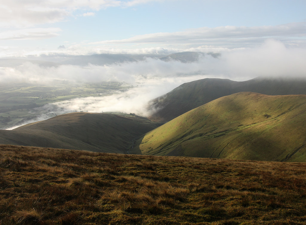
On foggy days the flat land below can look like an expanse of cotton wool with tufts of trees pushing through it. Beneath that pall the people of the villages and farms are groping in the dark, while on Sutton Bank top the sun sparkles in a sky of unclouded blue.
James Herriot: from View from Sutton Bank Top in James Herriot's Yorkshire, 1979
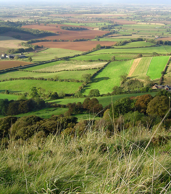
Sutton Brow Views. The view from Sutton Brow with Gormire farm to the right and Hood Grange to the left and far reaching views across The Vale of Mowbray: photo by Scott Rimmer, 11 September 2004

Views from Roulston Scar. Sutton Bank, or Roulston Scar to give its precise name, is Yorkshire's largest hillfort and is well known as the home of Kilburn White Horse, created in 1857, and of the Yorkshire Glider Club, founded in 1933. But very few people are aware that the promontory is also the site of one of the most important prehistoric monuments in the region: a massive hillfort built in the Iron Age, around 400 BC, discovered not so long time ago! The view north is of the Hambleton Hills: photo by Scott Rimmer, 26 November 2004

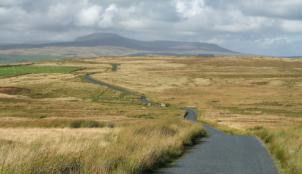
Views from Sutton Bank. Fantastic views from Sutton Bank across to the Yorkshire Dales (on a clear day!) with Hood Grange in the centre of the frame: photo by Scott Rimmer, 26 November 2004

View west from the Cleveland Way at Live Moor, near Heathwaite, North Yorkshire: photo by James F. Carter, 30 September 2006
Sutton Brow, North Yorkshire, panorama #2. A panorama of Roulston Scar and Hood Hill from Sutton Brow: photo by welsh snapper (Richard Jones), 8 April 2009

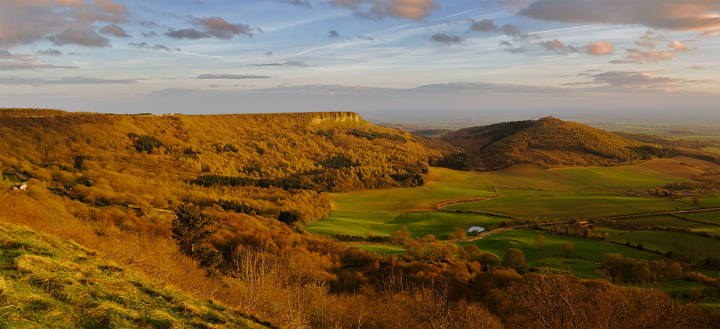
Sutton Brow, North Yorkshire, panorama #3. A wider panorama of Roulston Scar, Hood Hill, the Vale of York, and Gormire Lake from Sutton Brow: photo by welsh snapper (Richard Jones), 8 April 2009
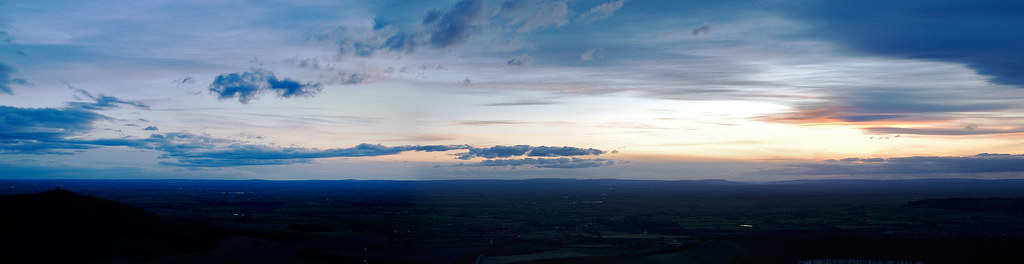
Sutton Brow, North Yorkshire, panorama #1. Panorama over a 140° arc from Sutton Brow. The sun had set down Wensleydale: photo by welsh snapper (Richard Jones), 7 April 2009

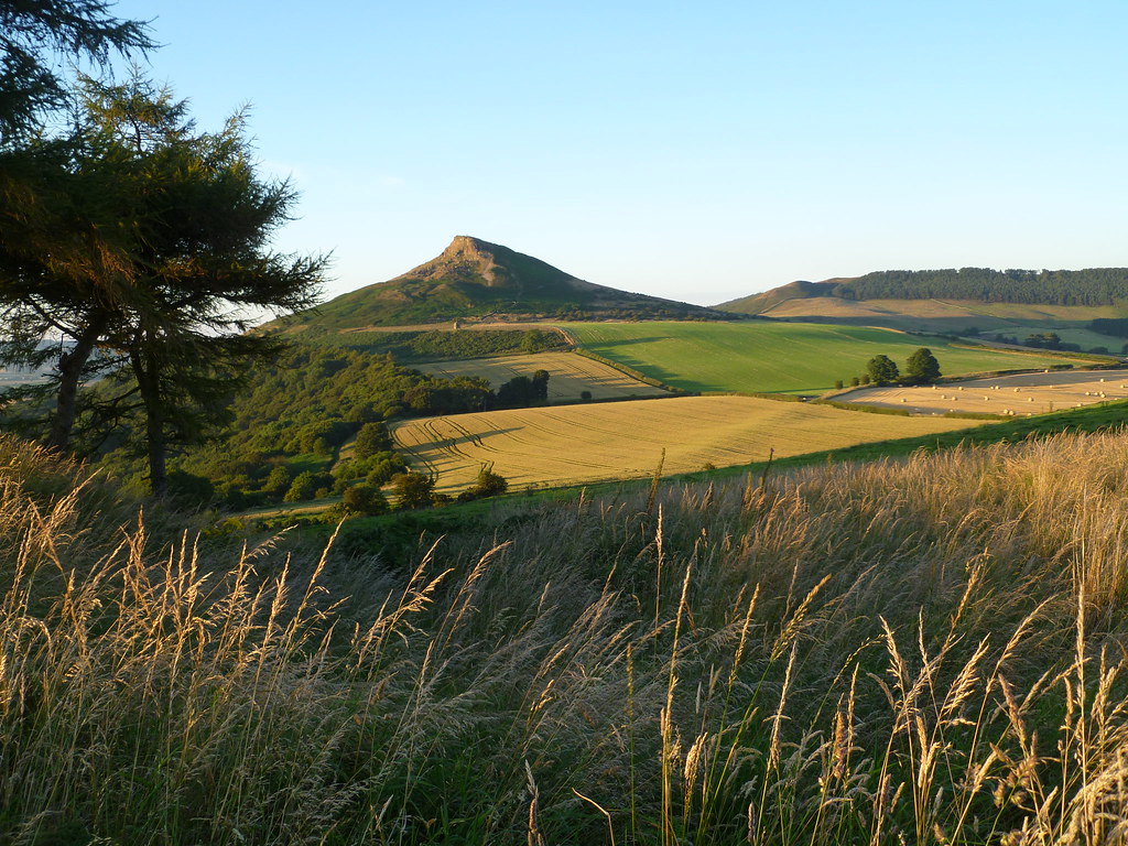
Roseberry Topping, North Yorkshire, with the landscape opening out to the Cleveland and Hambleton Hills: photo by stupiduglyfool, 16 September 2012

Black Hambleton, North York Moors: photo by UncleBucko, 2 September 2012

Black Hambleton, North York Moors: photo by UncleBucko, 2 September 2012
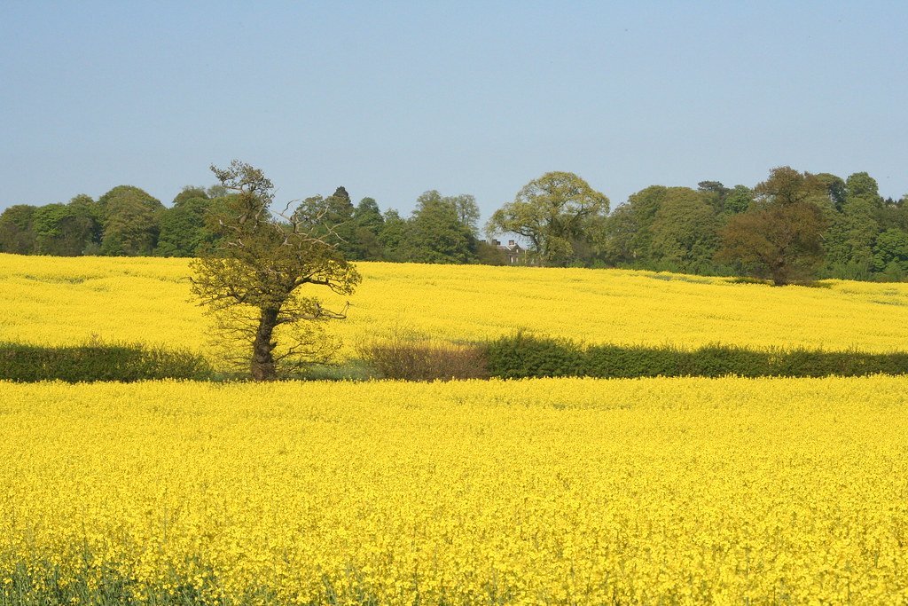
Rape fields, Hambleton Hills, North Yorkshire: photo by Sara Richer, 10 May 2006
Looking south from Great Dummacks, Howgill Fells near Sedbergh, Yorkshire Dales National Park. Having reached this point, 645 m asl (the summit, at 663 m, was ~100 m behind the camera, with often-photographed Cautley Crag a further ~100 m to the NE), I was pleased that, as anticipated, the morning sun had burned the initially dense fog off the high ground, leaving photogenic mist in the valleys. However, I was less pleased to re-encounter that humidity, immediately being recycled as cloud over the tops –- a moment after I took this photo, thick cloud rolled in and I was left navigating by compass and memory. The ridge on the left of Grimes Gill is Fawcett Bank Rigg, with Middle Tongue sunlit on the right. Beyond is Hobdale Gill, then Knott (429 m), rising to the right to Sickers Fell (498 m within the cloud), itself a shoulder on the ridge towards Arant Haws and Calders. The hill on the far side of the fog-filled confluence of the Rawthey and Dee valleys at Sedbergh, hidden behind Knott, is Combe Top, reaching 524 m at the eastern corner of Middleton Fell, 9½ km away. Further away (~13 km) is Crag Hill (682 m)/Great Coum (687 m), on the far side of Dentdale; Aye Gill Pike (556 m) is on this side. Even further away, Whernside (736), North Yorkshire's highest point, forms the horizon, 16 km from here: photo by Ministry, 6 October 2012
Crossing Clapham Common, Keasden, Forest of Bowland AONB, North Yorkshire. The single-track Keasden Road crosses open moorland from Bowland Knotts (and, before that, Stocks Reservoir in the Hodder Valley) acting as the spine of the very scattered settlement of Keasden (a series of hill farms seemingly with little more in common than this linking road, and each ~300 m from even that), then on to Clapham at the foot of Ingleborough. Cowsen Gill Bridge is at ~295 m asl, and the road vanishes over brow of the moor at ~305 m at Dovenanter, but the summit plateau of Ingleborough reaches 724 m and Whernside, North Yorkshire's highest point (736 m) is in cloud to its left. Keasden Road is one of four north-south routes across the Bowland Fells. Well, three if one doesn't count Hornby Road, the off-road track over Salter Fell. Okay; two, as the Cross of Greet road from Slaidburn to Bentham is currently closed. So there's the Trough of Bowland, linking Dunsop Bridge and Wyresdale/Lancaster, and this. Or one could drive round the outside, I suppose: photo by Ministry, 21 August 2011: photo by Ministry, 21 August 2011
Roseberry Topping, North Yorkshire: photo by Becca L (Rebecca Lightfoot), 9 August 2012

Path to Roseberry. Along the eastern edge of Whinns Quarry. Roseberry Topping is in the distance: photo by Mick Garrett, 28 December 2005

Middleham High Moor Gallops. A view of Middleham High Moor taken when the heather was at its best with a view of Penhill in the background: photo by Anthony Harrison, 28 August 2007

One of the Whernside Tarns. There are four Whernside tarns. This is one of the smaller ones and the most easterly: photo by Steve Partridge, 21 April 2006

Freezing fog. Below West Fell End on the path down the length of Whernside. Looking north east along the ridge wall: photo by John Illingworth, 1 February 2006

View of the Hambleton Hills across the Vale of York from Well, near Bedale, North Yorkshire: photo by Mirrored-Images...Out of Action (Jilly W), 5 December 2011
Whernside in the snow: photo by Travelling Simon, 20 February 2010
This post for A (with a bit of Roseberry Topping)


14 comments:
And for those who've been dying for it -- a fifteen second capture of sights and sounds from the top.
Tom,
"Every day is different up here" (too).
2.5
light coming into sky above black plane
of ridge, song sparrow calling in field
in foreground, sound of wave in channel
a few days later, “appeared”
closer to “repetition”
means that is beyond itself,
becomes, in that case
silver line of sun reflected in channel,
fog on horizon to the left of the point
Steve, the North Yorkshire weather report, as of the present, with different days seemingly coming and then quickly passing, from moment to moment:
Today
Very windy this morning, with gales in places, and scattered snow showers. Some sunny spells for a while, before cloud increases and outbreaks of rain and sleet, with hill snow, arrive this afternoon. Later the wind eases a little.
Tonight
Initially rain or sleet showers along the coast, clear periods inland. Later cloud arrives from the north, bringing snow inland and slight accumulations, but rain or sleet to the coast.
Beautiful. Makes me want a vacation . . . A visit to some place with a view.
Yes, me likewise, and then some -- and while we're at it, let's add to our list of desiderata a congenial and kindly vet who doesn't balk at making housecalls, in any sort of weather.
(Angelica has been re-reading the books of the wonderful James Herriot, whose spirit was of this place though he was not born there.)
love the yellow...!
It's the cloud shadows on the hills that move me and all those subtle shifts in colour.
I don't know this part of Yorkshire so well. That far west he has in view I know better. My brother studied in Sheffield and it would be a matter of a few minutes walking out from his terraced to reach the Pennines.
Herriot without any grand hoohah attends to the landscape as something living, as spirit. You have to be part of that territory to do this.
A has something of wild (and English) beauty here.
I think I'm going to follow Angelica's lead and re-read James Herriot, too. I could do with some things 'bright and beautiful,' and that (along with these photos and video) is as close as I'm likely to get to a trip to Yorkshire any time soon.
Before your previous posts re Herriot and Blake’s lamb…I had been rereading James Herriot (James Wight) and been immersed in his bio, anecdotes, animals, pensioners….and his wonderful life and his wonderful ‘small hands’ that could fit inside of and turn a baby lamb jammed like a cork in its mother’s womb! Those descriptions of a country vet’s practice and life were/are a brain cleanser and heart replenisher. That dog with one woof in him a delight. Herriot’s sensibility was as great as those views from the glider in the link you provided. With an aerial view of the Horse of Kilburn. Thanks for those exquisite pictures…and a fence of stones like those Herriot described. Your blog is a pleasure to visit, a symphony of people and place.
The photographs, the Herriot, the weather-exhilarating!
Delighted to hear that our delight in James Herriot -- well, Alf Wight, to call him by his real name -- is shared.
His legend is tended by a dedicated following... in Manitoba, of all places.
Some biographical bits from the Herriot/Wight scrapbook.
Tom,
Thanks for North Yorkshire weather report -- beautiful.
Clear here this morning, northwest wind kicking up.
Spent 10 years of my life leading groups of 'difficult' adolescents on the White Rose walk from Sutton Bank to Rosebury- wonderful to do on a clear day in Autumn although some of us locals aren't that keen on the Herriot legacy.
Thank you very much John, nothing like a bit of local knowledge to lend credence to the view. That walk up the hills cannot but have been a blessing upon the souls of those troubled kids.
And at the same time I'd covet the chance to join in that climb (not much chance any more, I'm a pretty creaky old geezer), I'm also aware that the rafts of tourists brought in by the Herriot "industry" (none of his doing of course, but still) would have been a mixed blessing for the region. Revenue is not everything, after all, and that is something (much like respect) which is not always easy to explain to contemporary folk.
In any case, the countryside was meant to be the real interest here, and I suppose I'm guilty with this post of wanting to revisit that countryside vicariously -- or "virtually", as is said.
(I did by the way get some hints of the tangible "feel" of the place on several quiet hiking -- and hitch-hiking, that long lost form of transit -- explorations, while spending a good part of the 1960s living on the North Sea, down the coast a bit; so the effects of that North Sea climate, in particular that bitter little "thin wind" which could seem to cut through one's bones, steady and relentless, will never be forgot.)
Post a Comment